
Principle and application
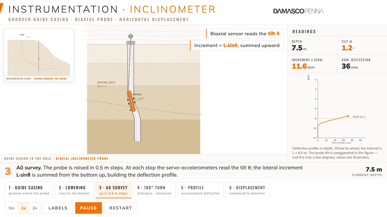
The inclinometer shows what happens inside the ground. A casing with four grooves is installed in a vertical borehole, with its toe anchored in stable ground below any expected movement. In each survey, a biaxial probe travels along the casing and measures its tilt every 0.5 m; comparing each reading with the initial one gives the profile of horizontal displacement with depth.
The result answers the three questions that matter for risk management: whether the ground is moving, at what depth the shear surface lies and whether the movement is speeding up or slowing down. Movements of a few millimetres show up in the profile long before any crack appears at the surface.
Typical applications: natural and cut slopes, earth and tailings dams, embankments on soft soil, braced excavations, retaining walls and hillsides along highways and railways.
How the inclinometer reads movement
Interactive animation of the survey. The biaxial probe is lowered down the grooved guide casing and, rising in 0.5 m steps, measures the tilt of each segment. Where the ground shears, the probe tilts, and summing those tilts reveals the horizontal displacement with depth.
Installation step by step
Borehole and casing
A vertical borehole crosses the zone of interest and extends a few metres into stable ground. The casing is assembled with its grooves aligned to the expected direction of movement.
Annulus backfill
The gap between casing and borehole is filled with a cement bentonite grout of stiffness compatible with the soil, so that the casing moves with the ground.
Baseline reading
After curing, repeated initial readings set the zero. Every later survey is compared with them.
Survey readings
The probe goes to the bottom and is pulled up, stopping every 0.5 m, in two passes rotated by 180°, which cancels the sensor bias.
Analysis and alerts
Cumulative displacement and rate profiles are compared with the alert levels set in the monitoring plan.
Quality controls: casing checked for groove spiralling, casing toe in stable ground, readings in two passes (0° and 180°) with checksum within tolerance, periodic probe performance verification (ASTM D7299), same probe and cable throughout the series and a record of the conditions of each survey.
According to ASTM D6230
| Standard | ASTM D6230 (monitoring with inclinometers) and ISO 18674-3 (inclinometers), with the general rules of ISO 18674-1 |
|---|---|
| Probe verification | ASTM D7299 |
| Technical reference | Dunnicliff, J. Geotechnical Instrumentation for Monitoring Field Performance (Wiley, 1993) |
| Measured quantity | Cumulative horizontal displacement in two orthogonal directions (A and B axes) |
| Reading interval | Every 0.5 m, from the bottom to the top of the casing |
| Frequency | Set in the monitoring plan and increased in critical periods such as heavy rain and excavation stages |
| Deliverable | Installation as-built, reading sheets, cumulative displacement and rate plots versus depth and an interpretation report |
Carried out to the same QA/QC, HSE and site standards as every Damasco Penna service, described in Quality and field operations.
Frequently asked questions about Inclinometers
What is an inclinometer used for?
To measure horizontal ground displacement with depth. It shows whether the ground is moving, at what depth the shear surface lies and how fast it moves, which is essential information for the safety of slopes, dams and excavations.
What is the difference between an inclinometer and a surface monument?
A surface monument shows movement of the ground surface; an inclinometer shows movement along the depth and locates the shear surface. The two complement each other in a monitoring plan.
How often are readings taken?
The frequency is set in the monitoring plan according to risk and construction stage, and it increases in critical periods such as heavy rain, dam raising and excavation stages.
Can the inclinometer be automated?
Yes. In-place inclinometers, with a chain of sensors inside the casing connected to a datalogger, provide continuous readings and remote alarms in the most critical sections.
Related services
Inclinometers for your project
Tell us about the project and we will put together the monitoring plan and the quote.